Either way you read it, it's the same!
It is an understatement to say the Panama Canal is an unforgettable trip through history. The feeling of traveling through the massive locks, the scenery, large Lake Gatun in the Canal and the engineering masterpiece are difficult to put into words.
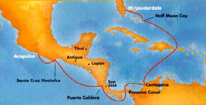
We flew out of Phoenix the morning of Sunday, October 10th for Fort Lauderdale, Florida, where we would board our Holland America ship on Monday. We spent Monday morning with Bruni, a friend who lives in Fort Lauderdale, and she gave us a tour of the city before taking us to Port Everglades Harbor. We had a great time catching up, as we hadn't seen each other for about eight years.
Now for a little history of cruising. When you take a cruise, you follow the paths of the early pirates. The word "cruising" comes from the Dutch word "kruisen," which means "to cross." While the pirates were searching for treasure ships to plunder, they would sail in a zigzag pattern moving through the shipping lanes. This form of sailing was not done on schedule, so many years later yacht owners adopted the word and applied it to any carefree pleasure voyage. The tradition of smashing a bottle of champagne on the hull when launching a new ship evolved from early sacrifices to the gods invoking their protection for the new ship. Originally, per Icelandic sagas, human sacrifices were offered. Virgin maidens were originally tied to the ground between the launching rollers and were sometimes immortalized by having their likeness carved onto the hull of the ship. Animals replaced humans, and then in medieval times red wine was used, and finally champagne was substituted and is used today.
Monday afternoon following our life jacket and life boat emergency evacuation drill, we left Fort Lauderdale and sailed east into the Gulf Stream, heading for the New Providence Channel and Nassau, Bahamas. We were originally scheduled for a day at Holland America's private island in the Bahamas, but due to hurricane Floyd recently the itinerary was changed to Nassau. We walked from the pier into town and enjoyed shopping and people watching.
The Bahama Islands were first called the Lucayanas, after the Indian tribe that, with the Arawaks, inhabited the islands. There are more than 700 islands and islets that were owned by the Spanish until 1647 when a group of English refugees in search of religious freedom took over. In downtown Nassau is a statue of Queen Victoria adorning the compound at Parliament Square where the court house and government offices are located, along with a building dating to 1797, originally being a jail and in 1873 becoming a public library. To the south is Queen Anne's Staircase, carved out of the coral rock by slaves almost two centuries ago.
Tuesday night we entered the Atlantic Ocean. The next two days were spent at sea, on the Atlantic Ocean passing the easternmost tip of Cuba, then entering the Caribbean Sea and passing the westernmost tip of Haiti, heading to our next port of call, Cartagena, Colombia. Cartagena was founded in 1533 and throughout the 16th century Spain governed it through a system of Viceroys. When the Spanish conquistadors discovered the interior of Colombia was rich in gold and emeralds, wealth of all kinds flowed into Cartagena for shipment to Spain, which invited pirate attacks. In defense of the city, King Felipe II ordered a protective wall be built around it. The streets were intentionally made narrow and crooked, designed for protection during assault. Sir Francis Drake led the most famous assault, in 1586, as he made it into the Cartagena harbor, but accepted a 10 million peso ransom for not burning the city. After this, Spain wanted to fortify the city and a massive 25-mile wall of coral was built around the Old City, completed in 1686. Today it is a bustling metropolis of 850,000 people and a busy maritime and industrial center.
Many forts were built to defend the city, and we toured one of them, San Felipe, begun in 1657 and captured and destroyed by the French in 1697. It was rebuilt between 1762 and 1769 and remains an impressive structure in Cartagena. We opted for a city tour in Cartagena, so we saw many parts of this huge city, including the Manga residential area, where some mansions have been restored to their original splendor. We continued up a narrow, winding road to the monastery of La Popa, which affords a breathtaking view of the harbor and city. From there we passed through Simon Bolivar square and the Inquisition Palace and continued on to the Church of San Pedro Claver. We saw a short folkloric show at an 18th century fort, San Sebastian del Pastelillo, built to protect Cartagena's emeralds and gold. We stopped to do a bit of shopping before returning to the ship, as emerald and souvenir stores were in abundance! In the evening we left Cartagena, sailing through the Bahia de Cartagena and entering the Caribbean Sea heading west to Panama, arriving at the breakwater of Cristobal, Panama around 7:00 a.m. The Pilots boarded at 8:00 a.m. and 9:30 a.m. we arrived at Gatun locks. (In other places when local pilots board a ship they are there only to advise the ship's captain and he makes the final decisions, but in the Panama Canal the orders of the pilot rule, and the ship's captain is not in charge again until the pilot disembarks.) About 10:00 the first lock opened, and we entered Gatun Lake and the Panama Canal. It was definitely a strange site to see freighters and barges on a lake, especially in the Panama Canal. Our transit of the Canal took about eight hours, all during daylight. The majority of commercial ships transit the Canal at night so the tourist ships have the benefit of daylight transit. Canal souvenirs could be purchased only while actually in the Canal.
The Panama Canal was opened to commercial ship traffic on August 15, 1914. Since that time approximately 600,000 ships carrying more than 4 billion tons of cargo have gone through the waterway. Savings to shipping and ultimately to consumers are enormous and entire trade areas and industries have been developed as a result of its opening. Its geographical position has made it of unique importance in the development of Latin America. Though the basic design, of the Canal remains the same as when it opened in 1914, there have been physical improvements and new procedures instituted to keep pace with the growing demands of the world's maritime traffic. According to the 1989 Lloyd's Register of Shipping, there are 65,000 commercial ships of over 100 gross tons in the world's inventory of ships. Of these, about 97 percent are able to transit the Canal. The estimated capacity, from an engineering point of view, is about 27,000 ships per year. Currently the Canal is handling around 14,000 transits per year and is, therefore, far from saturation.
Suffice it to say that it was a memorable day from entering the Gatun Locks on the Atlantic side to sailing under the Bridge of the Americas and entering the Pacific Ocean - with the sun setting to the EAST of us, over the Atlantic Ocean! As we exited the Canal we got a look at the battleship USS New Jersey, which was waiting to transit the Canal to be retired.
We thought it interesting that the ship sold Panama Canal souvenirs ONLY while IN the Canal. There was a display in the gift shop during the cruise, but with a sign stating that the items were available only during our transit of the Canal. They also served Panama Rolls, a sweet bread filled with crushed mandarin oranges and vanilla custard. Another interesting fact we learned is that the Pacific and Caribbean water levels are about the same, but the Pacific's tides are much higher and if a waterway had been dug instead of a canal with locks, ships could possibly have surfed from the Pacific to the Caribbean. Originally, real mules were used to guide the ships through the locks, and when motorized vehicles replaced the animals, the term "mule" continued to be used. In the Gaillard Cut is a hill named "Gold Hill". When workers were being recruited, they were told there was gold in one of the hills, so many men agreed to go to work on the canal project, only to find out that in fact there was no gold there and that this was known to the employers.
After leaving the Canal at Balboa, we started out on a southerly heading toward Punta Burica, the southernmost position of our voyage. Early the next afternoon we entered Golfo Dulce Cabo Matapalo and eventually entered Golfito Harbor, situated in the northeast part of the bay, a busy port for the banana export business of Puerto Rico. After being cleared by Costa Rican authorities, our ship headed northwest toward Puerto Caldero, our next stop.
The calm, sheltered waters of the Golfo Dulce provided a panoramic view of the rugged coastline of southwestern Costa Rica. Heavy rainfall sustains a tropical rain forest vegetation and made Golfito from the 1930's until the 1980's primarily a banana port, belonging to the Banana Company of Costa Rica. Palm oil is now the major crop with the Golfito port handling about one fifth of the Costa Rican seaborne trade. A roadway through the mountains connects this town to the Pan American Highway. Costa Rica is one of the leading areas of conservation in Central America with more than 10% of the country protected in national parks and preserves. This area contains the greatest biodiversity (variety of plants and animals) in Costa Rica, providing a home for over 500 species of trees, 140 species of mammals, 367 species of birds, 40 species of freshwater fish, and 117 species of amphibians and reptiles (including 32 species of snakes). For insect lovers, over 6,000 species have been identified to date. The park habitants provide a refuge for endangered animals such as the tapir, ocelot, cougar, harpy eagle (the largest bird of prey in the world), and the scarlet macaw. Other protected species include the crocodile, capuchin monkey, great tinamou, silky anteater, and the glass frog (name due to its transparent skin).
We opted for a Costa Rica "Countryside" tour offered by the cruise line. This was a 7 1/2-hour coach tour where we traveled the famous Pan-American Highway out of the coastal plains and into the mountains of Central America. The highway rises to vistas and panoramas displaying verdant costa Rican mountainsides, and the drama of the landscape is revealed with each turn of the road passing coffee plantations, sugar cane country, and small towns before arriving at a privately-owned colonial retreat. Here we had a homemade Costa Rican-style barbecue lunch under the mango trees while listening to a local band play German "oompa" music, which, of course, seemed out of place in Costa Rica. But then, it was Octoberfest time. After lunch we continued our tour and visited a coffee ranch, as they call it, rather than plantation. We sampled various coffees and toured parts of the ranch, ending, of course, with an opportunity to buy some of their coffee.
Costa Rica is located in the center of the Central American isthmus. Geophysically there are so many things going on that there is the feeling that it would take months to really explore it all. With less than 20,000 square miles, it is one of the smallest countries in Latin America. Costa Rica is bordered on the north by Nicaragua and on the south by Panama, two countries often in the international news and two countries profoundly different from this usually benevolent and prosaic land. To the east is the tranquil Caribbean Sea and to the west is the tumultuous Pacific Ocean. Costa Rica is as complex and perhaps more diverse than any place of its size on earth. Twenty-seven percent of Costa Rica is designated as national park, biological reserve, wildlife refuge or some other category of protected area, both private and public. That means more than a quarter of the country has been set aside in some capacity or other by human beings to protect it from the potential exploitation and ravages of other human beings. No other country in the world even comes close to such a statistic. There are other amazing statistics concerning Costa Rica. It has somewhere between 500,000 and a million total species of flora and fauna, 50,000 species of insects, 2,000 species of orchids, 208 species of mammals, 850 species of birds and endless thousands of species of moths and butterflies. In a space that occupies less than three ten-thousandths of the earth's surface are five percent of all of the plant and animal species on the planet. In the space of 75 miles across its narrowest width, the land goes from sea level to over 12,000 feet, and back to sea level. There are many landscapes and climates, and the wide variety of plants and animals they support. Costa Rica has a population of three million people who have a strong love and devotion to their homeland. Costa Rica has no standing army, but rather invests its funds into education. They have one of the highest literacy rates in the Western Hemisphere, a fact our tour guide was happy to tell us.
After crossing the Golfo de Tehuantepec, we were to reach Huatulco, which is located on the most western extremity of the Gulf. I said we "were to reach," because due to rough seas we could not anchor and tender in to shore. Tenders must be used to go ashore, and the Captain felt it was unsafe due to the extremely rough seas. Rough seas are common this area, and we spent a rough night at sea with the waves crashing against the ship's hull, rocking and rolling; thus, we were not surprised to find out we would not be going ashore.
Huatulco, Mexico is in the state of Oaxaca, located at the funnel of the North American continent where the Mexican Republic narrows down forming the Tehuantepec Isthmus. This location has brought about a great cultural and racial mixture. Sixteen native groups settled in the territory, continuing to the present day, with the Zapotec and Mixtec cultures predominating. Oaxaca is presently one of the few Mexican zones that keeps their traditions and customs unaltered and pure. According to legend, a wooden cross was brought to this area by one of the apostles, Saint Tomas, who left it in care of the native people. It is said that, over time, pieces of the cross were sent to various parts of the world. A replica of this cross is preserved today in a chapel in Huatulco.
Cortez used Huatulco as his base for trade and exploration. Its importance declined by the end of the 16th century with the development of the port of Acapulco for international trade with Asia. With improvements in public services and communication systems, the population has grown substantially. As a result, Bahias de Huatulco has transformed into a modern and important tourist resort. After bypassing the Port of Huatulco, we first sailed to the southwest, but after clearing the last cape we began sailing northwest, following the Mexican coastline to Acapulco, where we opted to spend three days in the sun before returning home to the Fall weather of Prescott.
Acapulco was originally a part of the Aztec empire, though no major ruins remain in the area. After the arrival of Cortez and his troops in 1530, it was quickly established as a busy ship building center and an important naval base for Spain. By the late 1500's, the city was a major port of call for treasure ships laden with silk, spices, porcelain and ivory from the Orient, and gold and silver from South America. Acapulco's busy industrial image regressed to a remote fishing village, and remained so until 1922, when a road linked it with Mexico City. Not until ten years later did people begin making the trip from the capital to Acapulco, where the only accommodations were boarding houses. The first hotel opened in 1934, but the real boom started after World War 11. Acapulco's natural beauty soon attracted the attention of international jet- setters, giving the town - now the heart of the Mexican Riviera - its world-renowned cosmopolitan air.
One of the highlights of our city tour of Acapulco was a demonstration of the famed cliff divers. Some of the men who do this are second and third generation divers and were taught by their fathers and grandfathers. They dive off the cliffs from various heights, the highest being 130 feet, into the water. They must time their dive with the surf coming in, and they dive between two high cliffs where there is reasonably rough water beating against the cliffs and the shore.
Our trip for 2000 will be a riverboat cruise from Amsterdam, Holland to Vienna, Austria, with three days before the cruise touring Brussels, and three days at the end touring Vienna. We will be adding that trip to this site toward the end of the year.